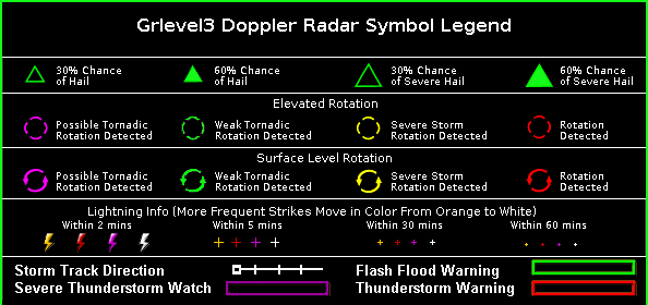
Nexrad Doppler Radar -

Radar images/loops now can be seen on tablets and smart phones with Android or Apple IOS operating systems.
|
|
||||
Storm Cell Attribute Table for Houston, Texas (KHGX) RadarRetrieved: Mon, 22 Jun 2026 23:39:46 -0400; Data valid day: 23; Data valid time: 0330Z (Refresh)
Algorithms produce this table. They may misrepresent observed conditions. |
||||
Show Location mode: Clicking the location button and placing your mouse over the radar display will indicate lat/long of the mouseover location. To see how far a shower or storm are from your location, you could, for instance, zoom the map, place the cursor over your approximate location, then press/hold the Shift key while dragging the mouse (left button down) to the location of the cell. This will display the bearing To the storm and distance. Zooming images: By default, zoom mode is turned on. To zoom a radar image, simply place cursor over the area that you wish to zoom on and left click the mouse. To un-zoom, hold CTRL key and left click mouse. Panning around images can be done by holding down left mouse button and moving the image. |
||||